
Newsletter
Categories
- 360i
- 3d
- 3D digital twin
- 3D modeling
- Abraham Lincoln
- accessory
- accuracy
- Accurate Survey Data
- ADA
- AEC
- aerial
- affordable
- African American
- Agents of Discovery
- Agricultural optimization
- American
- analysis
- Android
- Apglos Survey Wizard
- apps
- APRIL2024
- ArcGIS
- architecture
- As-built
- Asset inventory
- Asset management
- AUG2023
- augmented reality
- avenza
- aviation
- awareness
- Bad Elf
- Bad Elf GPS
- base
- base/rover
- Bluetooth
- Brain Processes
- breaks
- Broad Street pump
- buffer
- bug fixes
- CAD
- Cartography
- cholera outbreak
- Christmas
- Cognitive Maps
- Comic
- community
- Compliance
- Conference
- constellations
- construction
- construction professionals
- consultation
- coordinate systems
- CORS
- Cost Effective Surveying
- Cost Savings
- Custom GIS Solutions
- Custom Integration
- data collection
- data visualization
- datum
- DEC2023
- DEC2024
- Decision-making
- Design with Nature
- Digital Asset Mapping
- Digital delivery
- digital twin
- Dinosaur fossils
- Drone
- drones
- Ecological planning
- Ecology
- Economics
- Education
- Efficient Land Surveys
- Ellen Churchill Semple
- enablement
- engineering
- environmental determinism
- Environmental stewardship
- epidemiology
- equity
- error
- Esri
- Esri ArcGIS
- Extreme Accuracy
- Facility management
- fatalities
- FEB2024
- Field Maps
- field workers
- Fieldwork safety
- Firmware
- Flex
- Flex Mini
- ForeFlight
- Fossil location
- frequency
- fuel gauge
- GCP
- GCT
- Geodesy
- geography
- geoid
- geomatics
- geoprocessing
- geospatial
- Geospatial Data
- Geospatial Enablement Team
- geospatial professional
- Geospatial technology
- GET
- gis
- GIS implementation
- GIS solutions
- GIS Training
- GNSS
- GNSS receivers
- GPS
- GPS data collection
- GPS Integration
- Grid
- Ground
- ground control
- ground control targets
- Ground Penetrating Radar
- hazards
- high accuracy
- High Precision Survey
- high-accuracy
- history
- infrastructure
- injuries
- injury
- Inventor
- iOS
- JAN2024
- JAN2025
- jingle bells
- John Snow
- JULY2023
- JUNE2023
- JUNE2024
- JUNE2025
- land surveying
- Land surveyor
- land surveyors
- Land use
- Landscape architecture
- Laser
- Laser rangefinder
- LasterTech
- Layer cake analysis
- legacy
- LiDAR
- Local government
- LTI TruPulse 360i
- map
- Mapping
- MAR2025
- MARCH2024
- math
- mathematics
- MAY2023
- MAY2024
- May2025
- Mental Maps
- miasma theory
- Mock location
- Modernization
- Muhammad al-Idrisi
- NAD27
- NAD83
- NATRF2022
- navigation
- NDVI
- Newsletter
- NIR
- NMEA
- NOV2023
- NOV2024
- NTRIP
- oct2023
- oct2024
- Offline
- Offset
- Operations Optimization
- paddle
- pairing
- Paleontological fieldwork
- Paleontology
- pilot
- Pix4D
- PIX4D Catch
- Pix4Dcatch
- planes
- planning
- portable
- PPE
- Precise Mapping
- precision
- Precision Mapping
- President
- prevention
- protocols
- public funding
- public health
- public works
- quickcapture
- radio
- Rangefinder
- real-time
- real-time data collection
- Real-time monitoring
- reality capture
- Regulatory compliance
- remote data collection
- right of way
- Roger Tomlinson
- rover
- RTK
- Safety
- Safety Optimization
- safety tips
- satellite
- scanning
- SDK
- SEPT2023
- SEPT2024
- SEPT2025
- Sign Management Solution
- signals
- Simplified GIS
- Site survey package
- slope
- Small organizations
- solutions
- song
- Spatial analysis
- Spatial Data
- spatial mapping
- ssp
- STEM
- Stratigraphy
- support
- survey
- survey-grade
- survey123
- surveying
- Surveying Technology
- Sustainability design
- Tabula Rogeriana
- topographic maps
- topology
- total stations
- training
- Training solutions
- transition plan
- Tree Inventory
- Tree Management Solution
- Tribrach
- Tribrachasaur
- tron
- Urban Planning
- User Friendly Survey App
- Utility App
- utility design
- Utility pole measurements
- UTM
- Vegetation
- Washington DC
- Webmap
- WGS-84
- women
- workforce
- workplace
- workplace safety
- world
-


The Most Honest of Bad Elves

Did you know the 16th President of the United States of America, Abraham Lincoln, became a deputy county surveyor in Illinois in 1833. Yes you read that correctly, "honest Abe" was first an "honest surveyor!"
-
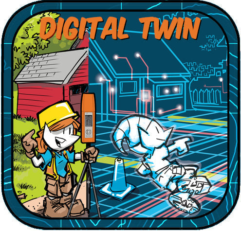

Like Tron? You will Love the Digital Twin
Step inside the "grid." Not "ground" for you surveyors out there. With Bad Elf GNSS powering precision and modern GIS tools lighting the way, reality and virtual design fuse into one electrifying experience! Read more about the digital twin today.
-


You gotta Pix4Dcatch ‘em all!
Turn your mobile device into a reality-capture Pokédex! Pairing Bad Elf GNSS with Pix4Dcatch lets you scan with precision, so every 3D model you collect is a legendary catch. Start catching them all today!
-
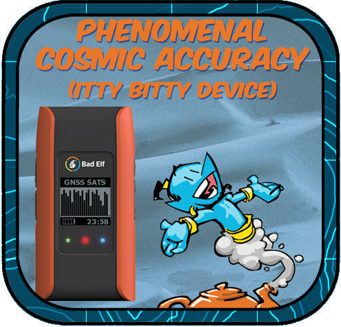

Phenomenal Cosmic Accuracy, Itty Bitty Device
Unlock survey-grade accuracy in the palm of your hand without the need of a genie and his lamp. At Bad Elf we call this Engineering Magic. Read more about how the Flex Mini Extreme achieves 2cm or better horizontal accuracy for only $1,499.99 USD.
-


Who Was Benjamin Banneker?
Benjamin Banneker was a self-taught African American inventor, astronomer, and surveyor. He helped map Washington, D.C., wrote popular almanacs, and spoke out against slavery. His work in science and civil rights made a lasting impact on American history.
-


ADA: Why Accurate Mapping of Accessibility Infrastructure Matters
ADA compliance matters because it ensures equal access, safety, and dignity for all people. Using Bad Elf GNSS with GIS enables fast, accurate, and affordable ADA asset mapping. This empowers teams to assess infrastructure, meet compliance standards, and secure funding with confidence.
-


Ellen Churchill Semple
Ellen Churchill Semple was a pioneering American geographer who advanced environmental determinism, broke barriers for women in STEM, and laid conceptual foundations for modern geographic information systems (GIS).
-


Why Aviation Professionals Choose Bad Elf
The Bad Elf Flex Mini is a cost-effective, high-accuracy GNSS receiver that seamlessly integrates with ForeFlight, making it the ideal GPS solution for pilots seeking reliable, subscription-free navigation.
-
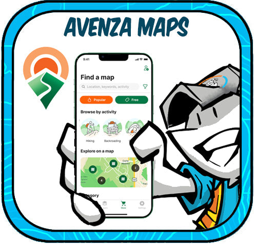

Field-Ready and Offline: Avenza Maps + Bad Elf GPS = Smart Mapping Made Simple
Avenza Maps paired with Bad Elf GPS receivers like the Flex and Flex Mini delivers high-accuracy, offline mapping for field professionals in forestry, utilities, environmental monitoring, and emergency response.
-


Flex Mini: Big GNSS Power in a Tiny Package
The Bad Elf Flex Mini is an affordable, high-accuracy GNSS receiver with RTK capability and a unique paddle mount that simplifies professional-grade mobile mapping for any smartphone or tablet.
-


Unlock Precision and Confidence with the Bad Elf Site Survey Package
The Bad Elf Site Survey Package (SSP) delivers an affordable, high-accuracy GNSS solution with customized hardware, expert training, and hands-on support.
-


The Baddest Elves of History - Muhammad al Isdrisi
Muhammad al-Idrisi, a 12th-century Moroccan geographer, revolutionized medieval cartography with Tabula Rogeriana, a highly accurate world map commissioned by King Roger II of Sicily, blending traveler accounts and data-driven mapping.


