Skip to content
    • Login
    • Create Account
Bad Elf
  • Home
  • Industries
    • Aviation
    • Commercial Aviation
    • GIS/Mapping
    • Marine
    • Photography
  • Products
    • Bad Elf Flex Mini
    • Bad Elf Flex
    • Bad Elf Flex Base/Rover
    • Bad Elf Scanning Kit
    • Legacy Products
      • Plug-in GPS
      • Legacy Bluetooth GNSS Receivers
      • Wombat (Piston Edition)
      • Wombat (Turbine Edition)
    • Accessories
    • Correction Services
      • Point One Navigation
      • GEODNET
  • Solutions
    • App & Hardware Partners
    • Bad Elf App
    • Bad Elf Flex App
    • Compatible Apps
    • Education/Non-profit
    • Esri Solutions
    • Laser Offset Workflow
    • Geospatial Services
    • Pioneer Package
  • Support
    • Documents & Manuals
    • GIS Resources
    • RTN Map
    • Training Videos
    • Cleared to Update
    • Developer Portal
    • Knowledge Base
    • Glossary
    • Contact Us
  • Store
    • Bad Elf Store
    • GSA Products
    • Resellers
  • News & Press
    • Educational Articles
    • Events
    • General News
    • Here! Here! Newsletter
    • Testimonials
  • Product Collections
    • Flex Mini
    • Flex Mini Support Equipment
    • Flex
    • Flex Support Equipment
    • Accessories for Flex
    • Flex Tokens
    • Accessories for Bluetooth GPS
    • Apparel
Total $0.00 0
    • Product Collections Navigation
    • Flex Mini
    • Flex Mini Support Equipment
    • Flex
    • Flex Support Equipment
    • Accessories for Flex
    • Flex Tokens
    • Accessories for Bluetooth GPS
    • Apparel
  • Home
    • Industries Navigation
    • Aviation
    • Commercial Aviation
    • GIS/Mapping
    • Marine
    • Photography
    • Products Navigation
    • Bad Elf Flex Mini
    • Bad Elf Flex
    • Bad Elf Flex Base/Rover
    • Bad Elf Scanning Kit
      • Legacy Products Navigation
      • Plug-in GPS
      • Legacy Bluetooth GNSS Receivers
      • Wombat (Piston Edition)
      • Wombat (Turbine Edition)
    • Accessories
      • Correction Services Navigation
      • Point One Navigation
      • GEODNET
    • Solutions Navigation
    • App & Hardware Partners
    • Bad Elf App
    • Bad Elf Flex App
    • Compatible Apps
    • Education/Non-profit
    • Esri Solutions
    • Laser Offset Workflow
    • Geospatial Services
    • Pioneer Package
    • Support Navigation
    • Documents & Manuals
    • GIS Resources
    • RTN Map
    • Training Videos
    • Cleared to Update
    • Developer Portal
    • Knowledge Base
    • Glossary
    • Contact Us
    • Store Navigation
    • Bad Elf Store
    • GSA Products
    • Resellers
    • News & Press Navigation
    • Educational Articles
    • Events
    • General News
    • Here! Here! Newsletter
    • Testimonials
My Account
Access Denied
IMPORTANT! If you’re a store owner, please make sure you have Customer accounts enabled in your Store Admin, as you have customer based locks set up with EasyLockdown app. Enable Customer Accounts

Laser Offset Workflow - Esri ArcGIS Field Maps and Bad Elf Flex®

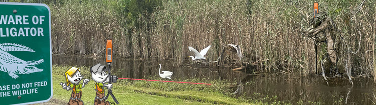
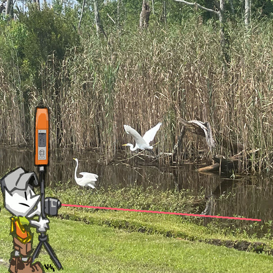
The simplified, intuitive laser offset workflow you wanted for those GNSS-challenged environments has arrived, thanks to a partnership between Laser Tech and Bad Elf. Save time, money, and effort when collecting the information you need in access-limited situations.

By integrating the Bad Elf Flex® GNSS receiver, LTI TruPulse® rangefinder, and Esri Field Maps you get high-accuracy location data to collect complete position and height information. Choose whether to connect the Flex and TruPulse hardware over wireless Bluetooth® or wired USB connection. The Flex then connects wireless over Bluetooth to your mobile tablet or phone to deliver positional data to Esri Field Maps.


Features at a glance

  • Standalone collection
  • Direct offset collection – ArcGIS Field Maps
  • Checklist-driven workflow
  • Operations supported
  • Range/range measurements
  • Range/azimuth measurements
  • Optional height measurement with any range measurement
  • ArcGIS toolbox included
  • Compatible with MapSmart on Android

Articles and Tutorials

Flex Firmware
Laser Calibration
Flex Configuration
Flex App Tutorial
Esri Field Maps Tools
ArcGIS Configuration

Bad Elf Flex

Bad Elf Flex democratizes GNSS and economizes field data collection.

Customers shared their needs for lower cost GNSS solutions with full RTK rover workflow. Bad Elf Flex Standard delivers, with 30-60cm accuracy all day, every day.

If you require an RTK survey-grade rover for use more than 30 to 40 days a year, consider the Bad Elf Extreme bundle. The Bad Elf Flex Extreme includes: fully unlocked RTK engine, multiple-constellation (MGNSS), and multiple-frequency (MFREQ) capability.

The Bad Elf Flex delivers comparative advantage in a total geospatial solution. A single GNSS receiver removes the need for deploying multiple devices in the field. Surveyors and their crews can have scalable accuracy, survey-grade capabilities in a single receiver. GIS managers focus on flexible field choices for work crews with varying skill levels. Businesses obtain operational and financial efficiencies. Bad Elf Flex effectively offers you several products in a single package through flexible software and configuration.

Some have even said it is Engineered Magic®!


Bad Elf Flex App

We designed the Bad Elf Flex app with a built-in NTRIP client, cross-platform architecture (Android & iOS), and complete receiver control.

The Bad Elf Flex seamlessly integrates laser offset collection using a unique checklist-based approach that delivers complete situational awareness and can correct common issues in field data collection. Say what you will about checklists, but they saved a budding aviation industry almost a century ago and then paved the way for making complex surgeries available to more people in need.

The Flex app confirms all critical items, thereby ensuring setup and configuration yields expected results. Should any circumstance occur that would invalidate the results, the Bad Elf Flex app highlights the checklist item that needs attention.

We store all GNSS and Laser metadata in an ArcGIS Field Maps layer to ensure data integrity. In addition, a provided ArcGIS toolbox allows for easy addition of metadata fields.

Invalid password
Enter
Contact Sales

Looking for advice on a product or service? Speak with a member of our staff.

Need Help?

We're here to help you with all of your Bad Elf products. Browse recent FAQ's, our Knowledge Base, Glossary, and more.

Support

Our staff is ready to assist with your detailed questions.

Quick links

  • Home
  • My Subscriptions
  • Newsletter
  • Support
  • Store
  • Blog
  • Careers
  • Contact
  • About Us

Policies

  • Accessory Warranty
  • GPS / Electronics Warranty
  • Hardware EULA
  • MAP Policy (US)
  • Privacy
  • Reseller Program
  • Returns
  • Shipping

Connect with us on Social Media

  • Facebook
  • Twitter
  • Instagram
  • LinkedIn
  • YouTube
Use left/right arrows to navigate the slideshow or swipe left/right if using a mobile device
  • Choosing a selection results in a full page refresh.
  • Press the space key then arrow keys to make a selection.

Shopping Cart

No products in the cart.