Access Denied
IMPORTANT! If you’re a store owner, please make sure you have Customer accounts enabled in your Store Admin, as you have customer based locks set up with EasyLockdown app. Enable Customer Accounts
News
Categories
- All topics
- accuracy
- Agents of Discovery
- Asset inventory management
- Bad Elf
- BIM
- Bluetooth
- Collector for ArcGIS
- construction
- corrections
- Critical infrastructure
- data collection
- DGPS
- Drone2Map
- education
- Esri
- Extreme Accuracy
- Field data collection
- Field Maps
- Flex
- Flex Mini
- Game
- GCP
- geospatial
- Geospatial data
- Geospatial professionals
- GIS
- GIS solutions
- GIS Training
- gisp
- GNSS
- gnss surveyor
- GPS
- GPS data collection
- ground control
- High Precision Survey
- high-accuracy
- High-accuracy GPS
- Infrastructure management
- ios
- JAN2025
- Laser
- launch
- Learning
- LiDAR
- Mapping
- marketing
- news
- NTRIP
- Ohio
- orthoimagery
- phantom
- pioneer
- PIX4D Catch
- Pix4Dcatch
- PointOne Navigation
- post-processing
- RINEX
- rtcm
- RTK
- SBAS
- scanning
- Survey
- training
- Training solutions
- update
- URISA
- Vendor
-
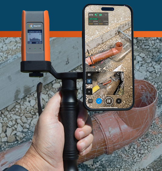
Bad Elf and Pix4D Launch Flex Mini Terrestrial Scanning Solution
Bad Elf and Pix4D have announced the launch of an integrated solution that brings high-accuracy 3D scanning to the palm of your hand. The Bad Elf Flex Mini Extreme GNSS receiver is now fully compatible with PIX4Dcatch, Pix4D’s mobile 3D scanning app, enabling field crews, inspectors, and asset managers to capture survey-grade 3D models using just a smartphone.
Invalid password
Enter
Use left/right arrows to navigate the slideshow or swipe left/right if using a mobile device