How to set ground control for drone operations

Setting ground control points (GCPs) is an essential step for achieving high-accuracy mapping drone flights. Here are the steps to follow to set GCPs for a 10-acre square area using a minimum of 5 GCPs and a few blind check points:
- Plan the GCP layout: The first step is to plan the layout of the GCPs. The GCPs should be distributed evenly throughout the project area, with at least one GCP in each quadrant of the area. The number of GCPs required depends on the accuracy requirements of the project, but a minimum of 5 GCPs should be used for a 10-acre square area.
- Choose GCP locations: Once the layout is planned, choose specific locations for the GCPs. The locations should be easily identifiable from the air and on the ground, and free from any obstructions that could affect the drone's flight or data collection.
- Mark the GCP locations: Once the locations are chosen, mark the GCP locations on the ground using highly visible markers such as brightly colored flags or painted targets. The markers should be large enough to be visible from the air and should be placed securely to ensure they will not move during the flight.
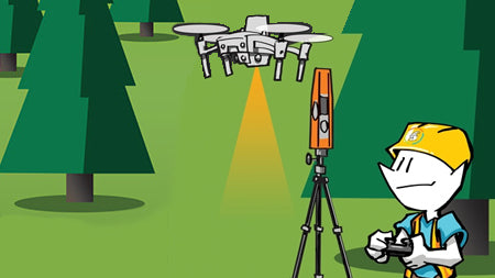
- Measure the GCP coordinates: Once the GCP locations are marked, measure the precise coordinates of each GCP using a survey-grade GPS or total station. Record the coordinates in a spreadsheet or database to be used later in the post-processing software.
- Capture the GCP data: During the drone flight, capture images of each GCP from multiple angles and heights, ensuring that the GCPs are clearly visible in each image. It's important to capture images of the GCPs both before and after the main flight to use for checking the accuracy of the final map.
- Use blind checkpoints: In addition to the GCPs, use a few blind check points, which are unmarked locations that will be used to verify the accuracy of the final map. These check points should be distributed throughout the project area and should be measured and captured in the same way as the GCPs.
By following these steps, you can ensure that the GCPs are accurately measured and captured, and that the resulting map is highly accurate. It's important to use high-quality equipment and software for both measuring the GCP coordinates and processing the drone data, and to carefully follow all safety and regulatory guidelines for drone flight.
Dr. Smilovsky is the Geospatial Solutions Director for Bad Elf, a GNSS technologies company. Dr S is a faculty member at Arizona State University teaching various GIS and design classes. He is a certified Geographic Information Systems Professional, a certified Arborist, and a Part 107 certified UAV pilot. As a geospatial evangelist, custom geospatial solutions provider, and geographic researcher Dr. S is widely versed in all things geodetic. He is a proud Geoholic!