Access Denied
IMPORTANT! If you’re a store owner, please make sure you have Customer accounts enabled in your Store Admin, as you have customer based locks set up with EasyLockdown app. Enable Customer Accounts
Archaeology made easy with the Bad Elf Flex Base and Rover
Author
Nikolas Smilovsky

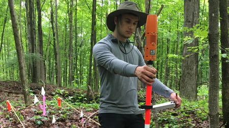
The Bad Elf Flex GNSS Base and Rover is an excellent solution for archaeology projects due to its accuracy, price, and versatility.
Accuracy: The Bad Elf Flex GNSS Base and Rover provides sub-meter accuracy in real-time, making it an ideal tool for archaeology projects that require precise location data. This high level of accuracy ensures that the data collected is reliable and can be used for a variety of applications, such as mapping, site analysis, and monitoring.
Price: The Bad Elf Flex GNSS Base and Rover is an affordable option compared to other high-precision GNSS receivers on the market. This makes it accessible to archaeology projects with limited budgets, without sacrificing accuracy or quality.
Versatility: The Bad Elf Flex GNSS Base and Rover can be used in a variety of field applications, including mapping, surveying, and data collection. Its compact size and wireless connectivity make it easy to transport and use in the field, even in remote or challenging environments.
In archaeology projects, the Bad Elf Flex GNSS Base and Rover can be used for a range of applications, such as mapping archaeological features, georeferencing excavations, and monitoring site changes over time. The receiver can also be used to collect data on cultural resources, such as historic buildings or artifacts, and to document and track changes to these resources over time.
Overall, the Bad Elf Flex GNSS Base and Rover provides a cost-effective and versatile solution for archaeology projects that require high-precision location data. Its accuracy, price, and versatility make it an excellent choice for archaeologists looking for a reliable and affordable GNSS receiver for fieldwork.
Nikolas Smilovsky
Dr. Smilovsky is the Geospatial Solutions Director for Bad Elf, a GNSS technologies company. Dr S is a faculty member at Arizona State University teaching various GIS and design classes. He is a certified Geographic Information Systems Professional, a certified Arborist, and a Part 107 certified UAV pilot. As a geospatial evangelist, custom geospatial solutions provider, and geographic researcher Dr. S is widely versed in all things geodetic. He is a proud Geoholic!
Invalid password
Enter
Use left/right arrows to navigate the slideshow or swipe left/right if using a mobile device