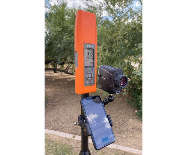
Bad Elf Introduces Laser Offset Workflow for Use in Esri ArcGIS Field Maps


Scottsdale, AZ, USA – Oct 26, 2021 – Bad Elf, LLC and Laser Tech (LTI), announce an integrated laser offset workflow for acquiring high-accuracy field data in GNSS-challenged environments. The new workflow integrates Bad Elf and LTI hardware in collaboration with ArcGIS technology from Esri, the global leader in location intelligence.
The Bad Elf Flex® connects to any LTI TruPulse® rangefinder over a wired or Bluetooth connection to deliver high-accuracy location data to Esri ArcGIS Field Maps. Field workers now efficiently complete position and height data collection in access-limited situations, saving time, money, and effort.
"This collaborative integration effort empowers field data collectors to focus their time, energy, and budget on creating and maintaining their systems of record, instead of troubleshooting systems integration issues. As Esri Partners in the Esri Partner Network, we are pleased to collaborate with LTI in offering a straightforward workflow to our customers,” said Larry Fox, VP Marketing and Business Development at Bad Elf.
“The ability to capture height measurements of an asset expands the data collection capabilities and ability to add more attribute data to the remote asset”, per Derrick Reish Sr. Product Manager at Laser Tech.
Bad Elf's app workflow focuses on enhancing productivity, reducing field collection difficulties, and mitigating quality issues. The Bad Elf app workflow runs on Android and iOS. Connection versatility minimizes operating system limitations and allows for app-based or standalone operation. Bad Elf also provides free Esri ArcGIS Desktop and ArcGIS Pro tools for offset-enabled point feature capture using the currently available ArcGIS Field Maps for iOS.
“The Bad Elf Flex, when paired with an LTI TruPulse rangefinder and ArcGIS Field Maps, delivers a powerful data collection solution. The innovative checklist-driven workflow delivers an intuitive, streamlined experience for advanced field workflows and the ability to provide a height calculation unlocks new opportunities for data capture,” Esri Product Lead Jeff Shaner said.
About Bad Elf, LLC
Bad Elf's line of GNSS receivers empower GIS and survey professionals to collect high-accuracy field data using any phone, tablet, or laptop. Our products work with any location-based app running on iOS, Android, and Windows. All Bad Elf’s Bluetooth receivers have an integrated LCD screen and intuitive user interface to provide status information and perform standalone data collection when needed.
Bad Elf’s products and services evolve within a framework of learning from our customers and applying our diverse and deep technical skills to deliver exceptional offerings that solve real-world challenges. Within this mindset, we seek to create technology that is sufficiently advanced to appear to the consumer as Engineering Magic®. While our solutions manifest as technology built for today, they envelop platforms that allow us to respond nimbly to continual change and opportunity explored in partnership with our customers.
For more information, please contact:
Larry Fox
Bad Elf, LLC
Phone: +1 (855) 422-3353 x 409
Email: larry@bad-elf.com
About Laser Tech
At Laser Tech, our passion is to equip industries with smarter measurement tools. We believe you can do your job quickly and safely without ever compromising accuracy or quality. Use our tools to streamline your workflow to fit shorter project cycles and smaller budgets. Laser offset measurements enable you to capture a distance, height, elevation value, or verify an azimuth direction or remote location with GPS. Measure encroaching vegetation, determine asset inventory, calculate span, sag, and tension values, create scaled detailed diagrams, and determine volumes with our offset laser mapping tools. Laser Tech’s complete solutions measure precisely, reliably, and accurately from safe terrain so you can plan and work with confidence.
For more information about Laser Tech or TruPulse range finders, please contact:
Derrick Reish
Senior Product Manager for Professional Measurement
Phone: +1 (303) 649-1000
Email: DReish@lasertech.com
www.lasertech.com
Bad Elf Flex® and Engineering Magic® are registered trademarks of Bad Elf, LLC.
TruPulse® is a registered trademark of Laser Technology, Inc.
Esri and ArcGIS are registered trademarks of Esri, Inc
About Esri
Esri, the global market leader in geographic information system (GIS) software, location intelligence, and mapping, helps customers unlock the full potential of data to improve operational and business results. Founded in 1969 in Redlands, California, USA, Esri software is deployed in more than 350,000 organizations globally and in over 200,000 institutions in the Americas, Asia and the Pacific, Europe, Africa, and the Middle East, including Fortune 500 companies, government agencies, nonprofits, and universities. Esri has regional offices, international distributors, and partners providing local support in over 100 countries on six continents. With its pioneering commitment to geospatial information technology, Esri engineers the most innovative solutions for digital transformation, the Internet of Things (IoT), and advanced analytics. Visit us at esri.com.

Larry Fox is VP of Marketing and Business Development at Bad Elf. He has over twenty years of experience as a product visionary, business development, and technology strategist. He is an innovator with the ability to identify, design, and launch complex hardware and software solutions, Fox has leadership experience with diverse and highly dynamic teams from startups to Fortune 500 companies. Throughout his career, he has patented expertise in GNSS/GPS technologies, mobile applications, web development, and wireless communication solutions. Larry is an active private pilot and is a part 107 operator.
