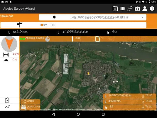
Stake-out and navigation to a point
Transform your staking process with the ASW, where precision meets ease. Simply select an element within our app and let the stake out function guide you. It effortlessly provides horizontal and vertical directions along with accurate distances, ensuring every stake is placed perfectly.
CAD support and GIS integration
Elevate your surveying workflow with Apglos Survey Wizard, where comprehensive mapping meets versatile exporting. Not only can you create detailed drawings with the intuitive layering system akin to AutoCAD and Microstation, but you can also customize your projects with an array of line types, weights, and colors.
What's more, ASW lets you export your maps to GIS shapefiles in any coordinate system, enhancing your ability to integrate and share data effortlessly!
PDF map exports
Capture and convey your mapping expertise through high-quality PDF exports from Apglos Survey Wizard. This powerful app allows you to create detailed drawings using a sophisticated layering system inspired by AutoCAD and Microstation. Customize your maps with a variety of line types, weights, and colors, ensuring that every detail reflects your precision.
Everything mapped and drawn in ASW can be seamlessly exported, stored, and shared as polished PDF documents, ready for presentation or further analysis.