Skip to content
    • Login
    • Create Account
Bad Elf
  • Home
  • Industries
    • Aviation
    • Commercial Aviation
    • GIS/Mapping
    • Marine
    • Photography
  • Products
    • Bad Elf Flex Mini
    • Bad Elf Flex
    • Bad Elf Flex Base/Rover
    • Bad Elf Scanning Kit
    • Legacy Products
      • Plug-in GPS
      • Legacy Bluetooth GNSS Receivers
      • Wombat (Piston Edition)
      • Wombat (Turbine Edition)
    • Accessories
    • Correction Services
      • Point One Navigation
      • GEODNET
  • Solutions
    • App & Hardware Partners
    • Bad Elf App
    • Bad Elf Flex App
    • Compatible Apps
    • Education/Non-profit
    • Esri Solutions
    • Laser Offset Workflow
    • Geospatial Services
    • Pioneer Package
  • Support
    • Documents & Manuals
    • GIS Resources
    • RTN Map
    • Training Videos
    • Cleared to Update
    • Developer Portal
    • Knowledge Base
    • Glossary
    • Contact Us
  • Store
    • Bad Elf Store
    • GSA Products
    • Resellers
  • News & Press
    • Educational Articles
    • Events
    • General News
    • Here! Here! Newsletter
    • Testimonials
  • Product Collections
    • Flex Mini
    • Flex Mini Support Equipment
    • Flex
    • Flex Support Equipment
    • Accessories for Flex
    • Flex Tokens
    • Accessories for Bluetooth GPS
    • Apparel
Total $0.00 0
    • Product Collections Navigation
    • Flex Mini
    • Flex Mini Support Equipment
    • Flex
    • Flex Support Equipment
    • Accessories for Flex
    • Flex Tokens
    • Accessories for Bluetooth GPS
    • Apparel
  • Home
    • Industries Navigation
    • Aviation
    • Commercial Aviation
    • GIS/Mapping
    • Marine
    • Photography
    • Products Navigation
    • Bad Elf Flex Mini
    • Bad Elf Flex
    • Bad Elf Flex Base/Rover
    • Bad Elf Scanning Kit
      • Legacy Products Navigation
      • Plug-in GPS
      • Legacy Bluetooth GNSS Receivers
      • Wombat (Piston Edition)
      • Wombat (Turbine Edition)
    • Accessories
      • Correction Services Navigation
      • Point One Navigation
      • GEODNET
    • Solutions Navigation
    • App & Hardware Partners
    • Bad Elf App
    • Bad Elf Flex App
    • Compatible Apps
    • Education/Non-profit
    • Esri Solutions
    • Laser Offset Workflow
    • Geospatial Services
    • Pioneer Package
    • Support Navigation
    • Documents & Manuals
    • GIS Resources
    • RTN Map
    • Training Videos
    • Cleared to Update
    • Developer Portal
    • Knowledge Base
    • Glossary
    • Contact Us
    • Store Navigation
    • Bad Elf Store
    • GSA Products
    • Resellers
    • News & Press Navigation
    • Educational Articles
    • Events
    • General News
    • Here! Here! Newsletter
    • Testimonials
My Account
Access Denied
IMPORTANT! If you’re a store owner, please make sure you have Customer accounts enabled in your Store Admin, as you have customer based locks set up with EasyLockdown app. Enable Customer Accounts

Announcement: Bad Elf Supports High Accuracy Location in Esri Collector

June 28, 2016
1 comment
Author Larry Fox
Larry Fox

We have all heard that phrase, “Location, location, location.”

But, what does this mean for the world of GIS? Obtaining location accuracy when collecting data delivers incredible value. The smart devices we carry daily in our pockets or the tablets we use for education and entertainment can only reliably deliver an accuracy of about five meters. For some, that is good enough. For others, it has to be better.

Consider standing on a point and looking five meters in any direction. If you are looking for a park bench in the middle of nowhere, it will be easy to find.

However, what if that point you have in your GIS is within a meter? It’s a lot easier to find and locate many items in an area if you know your location is about as far away as you can stretch your arms.

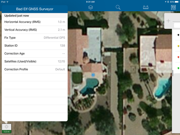
Bad Elf has been working with the Collector team at Esri to provide reliable and highly accurate location services directly to the Collector mobile applications across various platforms (iOS, Android, and Windows). The Bad Elf GNSS Surveyor was designed and built to provide mapping grade accuracy of about one meter when used with the built-in SBAS + PPP hardware. The GNSS Surveyor accessory, combined with Esri Collector, delivers an affordable solution for GIS data collection and mapping with the benefit of higher accuracy.

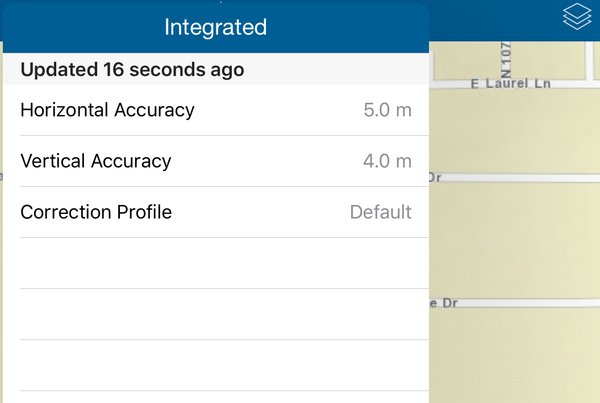
With the new high performance features built directly into the Esri Collector app, Bad Elf now supplies additional accuracy information right to the app. The screenshot below reinforces the fact that location supplied by the internal GPS is only OK.

Esri Collection 10.4 with High Accuracy Data Collection

Within the most recent beta Esri Collector app, there is a facility to configure external GPS receivers to supply higher accuracy location information. Bad Elf has fully integrated with this facility.

External GPS selection dialog in Esri Collector 10.4

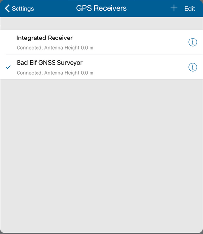
The result of this collaboration offers simplified workflow in addition to definitive location accuracy. With a simple set of configuration steps, Bad Elf receivers provide detailed location data directly to the Esri Collector app.

Field collection professionals now enjoy more robust information. The addition of detailed location information provides accurate, efficient, and economical workflows.

Esri Collector 10.4 integrated with Bad Elf GNSS Surveyor

High accuracy location was once difficult to attain, cumbersome, and costly. Bad Elf brings affordability and accuracy to the next generation of mobile data collection. If your question is “How accurate is my location information when I collect field data?” Bad Elf, combined with Esri Collector, is the solution.

Bad Elf is attending the Esri User Conference this week in San Diego, June 28-30. Please stop by and visit us in the UC Expo, Booth 533.

  • blog
  • launch
  • marketing
  • news
  • update
  • Share on Facebook
  • Tweet on Twitter
  • Pin on Pinterest

Larry Fox
Larry Fox

Larry Fox is VP of Marketing and Business Development at Bad Elf. He has over twenty years of experience as a product visionary, business development, and technology strategist. He is an innovator with the ability to identify, design, and launch complex hardware and software solutions, Fox has leadership experience with diverse and highly dynamic teams from startups to Fortune 500 companies. Throughout his career, he has patented expertise in GNSS/GPS technologies, mobile applications, web development, and wireless communication solutions. Larry is an active private pilot and is a part 107 operator.


1 comment

  • D
    September 13, 2016

    it seems best for real time data mapping,
    Remote sensing for forestry mapping
    is it best for this or not
    http://uizentrum.de/en/remote-sensing-services-2/forestry-mapping/

    - Dr. Sumi Thapa

Post a comment

Please note, comments must be approved before they are published

Invalid password
Enter
Contact Sales

Looking for advice on a product or service? Speak with a member of our staff.

Need Help?

We're here to help you with all of your Bad Elf products. Browse recent FAQ's, our Knowledge Base, Glossary, and more.

Support

Our staff is ready to assist with your detailed questions.

Quick links

  • Home
  • My Subscriptions
  • Newsletter
  • Support
  • Store
  • Blog
  • Careers
  • Contact
  • About Us

Policies

  • Accessory Warranty
  • GPS / Electronics Warranty
  • Hardware EULA
  • MAP Policy (US)
  • Privacy
  • Reseller Program
  • Returns
  • Shipping

Connect with us on Social Media

  • Facebook
  • Twitter
  • Instagram
  • LinkedIn
  • YouTube
Use left/right arrows to navigate the slideshow or swipe left/right if using a mobile device
  • Choosing a selection results in a full page refresh.
  • Press the space key then arrow keys to make a selection.

Shopping Cart

No products in the cart.