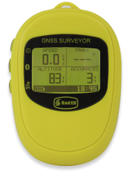
GNSS Surveyor
For real-time 1 meter* accuracy in
GIS, Mapping, Agriculture, & More!
Discontinued
Bluetooth GNSS Receiver & Datalogger with Barometric Sensor
The Bad Elf GNSS Surveyor delivers ~1-meter positioning out of the box to the iPad for use in GIS, mapping, agriculture, and survey activities. The GNSS Surveyor can record raw data and produce RINEX through the Bad Elf application for your post-processing needs.
- Supports Differential GPS (DGPS) Corrections
- Post Processing Ready
Mapping-Grade GPS, Powered by Bad Elf
The GNSS Surveyor is the most affordable 1 meter GNSS receiver available on the market today, and it works with a variety of GIS apps. Looking to learn more about use in GIS, see our GIS Resources for detailed infromation and advanced usage.

App Support
The GNSS Surveyor works out of the box with all location services aware iOS apps, but apps that integrate the Bad Elf SDK can access the advanced data and features available for sub-meter accuracy. Bad Elf has begun working with several developers to support the GNSS Surveyor directly. If you have an app and would like to support the GNSS Surveyor, please contact support today.
Affordable & Simple to Use.
At Bad Elf, we strive to create high quality, dependable products consistent with Apple's philosophy of "It just works!" Just turn on your Bad Elf GNSS Receiver and get to work. No complicated setup. Extra long battery life. No hassles.
Great Products. World-Class Service.
Need assistance? Bad Elf works hard to provide world-class customer service. If you have questions or concerns, please ask us. We stand behind our products and want you to be a delighted customer.
GIS/Mapping Features
- Stationary high precision GNSS as low as 1m out of the box with PPP in regions with SBAS coverage
- Post-processing support via RINEX conversion available in the Bad Elf app
- Differential GPS (DGPS) supported using Internet delivered RTCM 2.3 via built-in NTRIP client.
- 56 channel receiver supports GPS (US) and QZSS (Japan) constellations with SBAS (WAAS/EGNOS/MSAS), or GLONASS (Russia)
- Obtain altitude from GPS or from the built-in barometer, which can be calibrated to a known altitude or pressure
- No internet connection or monthly subscription required
Receiver Features
- Sample rate configurable to 10Hz
- View GPS or GLONASS status quickly with the backlit LCD
- All day battery life allows you to track for up to 35 hours (24 hours when streaming over Bluetooth)
- Access data logs directly from any PC or Mac using the included USB cable. GPS appears just like a USB thumb drive
- USB connectivity to PC or Mac provides streaming data, raw or NMEA
- Quickly acquires satellite lock without cell tower assistance. Hot start time
as quick as 1 second - IPX4 splash resistance makes this device ready for outdoors.
1In ideal conditiions, unobstructed view, with SBAS lock, device allowed to settle for at least 2 minutes
2Navigation possible on GPS/QZSS or GLONASS, simultaneous operation not available
Accuracy Statement
Bad Elf performs a variety of controlled tests on each product to test expected performance. Factors such as sattelite geometry, multipath, environmental conditions are considered in our testing process. Statements of accuracy are in ideal, or near ideal conditions, using best practices for field data collection.
GPS+PPP+SBAS Accuracy
The GNSS Surveyor is capapble of producing 1 meter CEP positional accuracy using GPS+PPP+SBAS. uBlox states that "PPP technology is made possible by stabilizing measurements of the distance between GNSS satellites and the receiver (pseudo-ranges) using carrier phase tracking. Additional accuracy is achieved from ionospheric correctional data received from satellite-based augmentation systems.
The image below represents a sample of what one can expect when using a GNSS Surveyor statically placed over a fixed location for 15 minutes. The center of the circle represents a know surveyed location that all of the measurements are calculated from. The requisite setup for this configuration includes:
- Greater than 6 satelites visible and locked
- SBAS signals being received and SBAS sattelites locked
- Clear view of the sky above 15 degrees from the horizontal
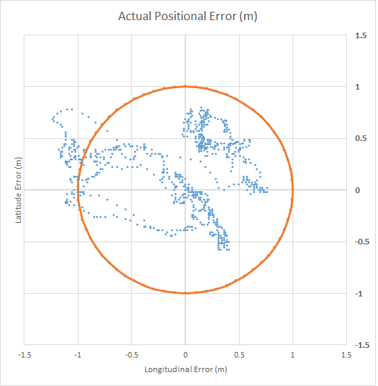
Conditions and results: Avg NSV=7, CEP (0.52m), 2DRMS @95% (1.26m)
DGPS Accuracy
The GNSS Surveyor is capapble of producing 1 to 1.5 meters (CEP) positional accuracy using DGPS and RTCM 2.3. Differential corrections are Code-Phase GPS corrections and require a nearby reference station sending data over NTRIP.
The image below represents a sample of what one can expect when using a GNSS Surveyor statically placed over a fixed location for 15 minutes. The center of the circle represents a know surveyed location that all of the measurements are calculated from. The requisite setup for this configuration includes:
- Greater than 6 satelites visible and locked
- RTCM 2.3 feed active for at least 2 minutes
- Clear view of the sky above 15 degrees from the horizontal
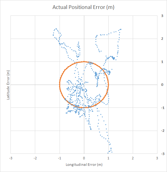
Conditions and results: Avg NSV=7, CEP (1.09m), 2DRMS @95% (2.72m)
Stand Alone Accuracy
Accuracy in non-SBAS regions or using GLONASS instead of GPS is typically between 2-2.5m CEP for static occupations. Stand alone performance is measured using the following parameters:
- Greater than 6 satelites visible and locked
- Clear view of the sky above 15 degrees from the horizontal