Skip to content
    • Login
    • Create Account
Bad Elf
  • Home
  • Industries
    • Aviation
    • Commercial Aviation
    • GIS/Mapping
    • Marine
    • Photography
  • Products
    • Bad Elf Flex Mini
    • Bad Elf Flex
    • Bad Elf Flex Base/Rover
    • Bad Elf Scanning Kit
    • Legacy Products
      • Plug-in GPS
      • Legacy Bluetooth GNSS Receivers
      • Wombat (Piston Edition)
      • Wombat (Turbine Edition)
    • Accessories
    • Correction Services
      • Point One Navigation
      • GEODNET
  • Solutions
    • App & Hardware Partners
    • Bad Elf App
    • Bad Elf Flex App
    • Compatible Apps
    • Education/Non-profit
    • Esri Solutions
    • Laser Offset Workflow
    • Geospatial Services
    • Pioneer Package
  • Support
    • Documents & Manuals
    • GIS Resources
    • RTN Map
    • Training Videos
    • Cleared to Update
    • Developer Portal
    • Knowledge Base
    • Glossary
    • Contact Us
  • Store
    • Bad Elf Store
    • GSA Products
    • Resellers
  • News & Press
    • Educational Articles
    • Events
    • General News
    • Here! Here! Newsletter
    • Testimonials
  • Product Collections
    • Flex Mini
    • Flex Mini Support Equipment
    • Flex
    • Flex Support Equipment
    • Accessories for Flex
    • Flex Tokens
    • Accessories for Bluetooth GPS
    • Apparel
Total $0.00 0
    • Product Collections Navigation
    • Flex Mini
    • Flex Mini Support Equipment
    • Flex
    • Flex Support Equipment
    • Accessories for Flex
    • Flex Tokens
    • Accessories for Bluetooth GPS
    • Apparel
  • Home
    • Industries Navigation
    • Aviation
    • Commercial Aviation
    • GIS/Mapping
    • Marine
    • Photography
    • Products Navigation
    • Bad Elf Flex Mini
    • Bad Elf Flex
    • Bad Elf Flex Base/Rover
    • Bad Elf Scanning Kit
      • Legacy Products Navigation
      • Plug-in GPS
      • Legacy Bluetooth GNSS Receivers
      • Wombat (Piston Edition)
      • Wombat (Turbine Edition)
    • Accessories
      • Correction Services Navigation
      • Point One Navigation
      • GEODNET
    • Solutions Navigation
    • App & Hardware Partners
    • Bad Elf App
    • Bad Elf Flex App
    • Compatible Apps
    • Education/Non-profit
    • Esri Solutions
    • Laser Offset Workflow
    • Geospatial Services
    • Pioneer Package
    • Support Navigation
    • Documents & Manuals
    • GIS Resources
    • RTN Map
    • Training Videos
    • Cleared to Update
    • Developer Portal
    • Knowledge Base
    • Glossary
    • Contact Us
    • Store Navigation
    • Bad Elf Store
    • GSA Products
    • Resellers
    • News & Press Navigation
    • Educational Articles
    • Events
    • General News
    • Here! Here! Newsletter
    • Testimonials
My Account
Access Denied
IMPORTANT! If you’re a store owner, please make sure you have Customer accounts enabled in your Store Admin, as you have customer based locks set up with EasyLockdown app. Enable Customer Accounts
HERE, HERE Tribrachasaur

The Epic Tale of the Tribrachasaur

June 24, 2024
Author Nikolas Smilovsky
Nikolas Smilovsky

Words: 509  | Reading Time: 5 Minutes

The Epic Tale of the Tribrachasaur

Introduction

In a time long forgotten, before maps charted the boundaries of kingdoms and theodolites marked the lands, there roamed an extraordinary creature known as the Tribrachasaur. As a humble land surveyor, I stumbled upon ancient texts that chronicled the tale of this wondrous dinosaur, whose abilities far surpassed our modern instruments. 

The Role of a Tribrach in Surveying

A tribrach, in the world of surveying, is a vital tool that ensures stability and precision. It is the foundation upon which our theodolites and total stations rest, allowing us to measure angles with unparalleled accuracy.

Key Features of a Tribrach:

  • Three adjustable legs
  • A leveling bubble
  • A mechanism that locks the instrument in place, ensuring it remains perfectly steady on any terrain

The Legend of the Tribrachasaur

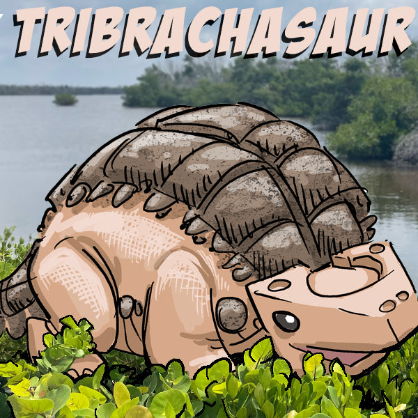
The Tribrachasaur, as the legend goes, embodied these attributes with an almost magical prowess. This dinosaur, standing as tall as a treetop, possessed three mighty legs that anchored it firmly to the ground. Its feet, each adorned with a crystal-clear bubble, ensured the creature maintained perfect balance at all times. The fourth leg is there, but is unneeded in most circumstances. The Tribrachasaur's head, equipped with eyes that could swivel independently, allowed it to measure distances and angles with pinpoint accuracy.

In those days, tribes and civilizations sought the guidance of the Tribrachasaur to map their lands and ensure the accuracy of their territories. The Tribrachasaur would traverse the rugged landscapes, its balanced steps leaving imprints in the earth that marked the boundaries with impeccable precision. Its eyes, like the lenses of our modern theodolites, captured every detail, from the highest mountain peak to the smallest pebble, ensuring no feature went unnoticed.

The Legacy of Precision and Honor

But the Tribrachasaur's story is more than just a tale of its remarkable abilities. It is a reminder of the importance of precision and honor in our craft. The ancient tribes revered the Tribrachasaur not just for its skills, but for its unwavering dedication to accuracy and truth. They believed that to honor the memory of the Tribrachasaur, one must always strive for the highest standards of data collection and mapping.

As land surveyors and cartographers, we are the custodians of this legacy. Every measurement we take, every map we draw, should reflect the meticulous care and precision of the Tribrachasaur. We must ensure our instruments are calibrated, our data is verified, and our work is conducted with the utmost integrity.

The story of the Tribrachasaur serves as a quirky yet powerful reminder of the importance of our role in shaping the world. It urges us to collect good data, to honor the memory of this mythical dinosaur, and to continue the legacy of accuracy and precision that it so majestically embodied.

So, as you set out with your tribrach and theodolite, remember the Tribrachasaur. Let its tale inspire you to uphold the highest standards, to ensure that every boundary is true, and to honor the spirit of this magnificent creature with every measurement you take. Happy Mapping!

Bad Elf Flex Mini Product Page
Bad Elf Geospatial Enablement Team
Bad Elf Flex Product Page
  • Cartography
  • JUNE2024
  • Land Surveying
  • Precision Mapping
  • Tribrach
  • Tribrachasaur
  • Share on Facebook
  • Tweet on Twitter
  • Pin on Pinterest

Nikolas Smilovsky
Nikolas Smilovsky

Dr. Smilovsky is the Geospatial Solutions Director for Bad Elf, a GNSS technologies company. Dr S is a faculty member at Arizona State University teaching various GIS and design classes. He is a certified Geographic Information Systems Professional, a certified Arborist, and a Part 107 certified UAV pilot. As a geospatial evangelist, custom geospatial solutions provider, and geographic researcher Dr. S is widely versed in all things geodetic. He is a proud Geoholic!

Invalid password
Enter
Contact Sales

Looking for advice on a product or service? Speak with a member of our staff.

Need Help?

We're here to help you with all of your Bad Elf products. Browse recent FAQ's, our Knowledge Base, Glossary, and more.

Support

Our staff is ready to assist with your detailed questions.

Quick links

  • Home
  • My Subscriptions
  • Newsletter
  • Support
  • Store
  • Blog
  • Careers
  • Contact
  • About Us

Policies

  • Accessory Warranty
  • GPS / Electronics Warranty
  • Hardware EULA
  • MAP Policy (US)
  • Privacy
  • Reseller Program
  • Returns
  • Shipping

Connect with us on Social Media

  • Facebook
  • Twitter
  • Instagram
  • LinkedIn
  • YouTube
Use left/right arrows to navigate the slideshow or swipe left/right if using a mobile device
  • Choosing a selection results in a full page refresh.
  • Press the space key then arrow keys to make a selection.

Shopping Cart

No products in the cart.