Skip to content
    • Login
    • Create Account
Bad Elf
  • Home
  • Industries
    • Aviation
    • Commercial Aviation
    • GIS/Mapping
    • Marine
    • Photography
  • Products
    • Bad Elf Flex Mini
    • Bad Elf Flex
    • Bad Elf Flex Base/Rover
    • Bad Elf Scanning Kit
    • Legacy Products
      • Plug-in GPS
      • Legacy Bluetooth GNSS Receivers
      • Wombat (Piston Edition)
      • Wombat (Turbine Edition)
    • Accessories
    • Correction Services
      • Point One Navigation
      • GEODNET
  • Solutions
    • App & Hardware Partners
    • Bad Elf App
    • Bad Elf Flex App
    • Compatible Apps
    • Education/Non-profit
    • Esri Solutions
    • Laser Offset Workflow
    • Geospatial Services
    • Pioneer Package
  • Support
    • Documents & Manuals
    • GIS Resources
    • RTN Map
    • Training Videos
    • Cleared to Update
    • Developer Portal
    • Knowledge Base
    • Glossary
    • Contact Us
  • Store
    • Bad Elf Store
    • GSA Products
    • Resellers
  • News & Press
    • Educational Articles
    • Events
    • General News
    • Here! Here! Newsletter
    • Testimonials
  • Product Collections
    • Flex Mini
    • Flex Mini Support Equipment
    • Flex
    • Flex Support Equipment
    • Accessories for Flex
    • Flex Tokens
    • Accessories for Bluetooth GPS
    • Apparel
Total $0.00 0
    • Product Collections Navigation
    • Flex Mini
    • Flex Mini Support Equipment
    • Flex
    • Flex Support Equipment
    • Accessories for Flex
    • Flex Tokens
    • Accessories for Bluetooth GPS
    • Apparel
  • Home
    • Industries Navigation
    • Aviation
    • Commercial Aviation
    • GIS/Mapping
    • Marine
    • Photography
    • Products Navigation
    • Bad Elf Flex Mini
    • Bad Elf Flex
    • Bad Elf Flex Base/Rover
    • Bad Elf Scanning Kit
      • Legacy Products Navigation
      • Plug-in GPS
      • Legacy Bluetooth GNSS Receivers
      • Wombat (Piston Edition)
      • Wombat (Turbine Edition)
    • Accessories
      • Correction Services Navigation
      • Point One Navigation
      • GEODNET
    • Solutions Navigation
    • App & Hardware Partners
    • Bad Elf App
    • Bad Elf Flex App
    • Compatible Apps
    • Education/Non-profit
    • Esri Solutions
    • Laser Offset Workflow
    • Geospatial Services
    • Pioneer Package
    • Support Navigation
    • Documents & Manuals
    • GIS Resources
    • RTN Map
    • Training Videos
    • Cleared to Update
    • Developer Portal
    • Knowledge Base
    • Glossary
    • Contact Us
    • Store Navigation
    • Bad Elf Store
    • GSA Products
    • Resellers
    • News & Press Navigation
    • Educational Articles
    • Events
    • General News
    • Here! Here! Newsletter
    • Testimonials
My Account
Access Denied
IMPORTANT! If you’re a store owner, please make sure you have Customer accounts enabled in your Store Admin, as you have customer based locks set up with EasyLockdown app. Enable Customer Accounts
RTN Map Header

Demystifying Public RTK Networks

August 8, 2024
Author Nikolas Smilovsky
Nikolas Smilovsky

RTK, or Real-Time Kinematics, is a technology that offers unparalleled precision in positioning, typically accurate to within a couple of centimeters. This level of accuracy, often referred to as "survey-grade," has traditionally been reserved for specialized applications due to the high cost and complexity of the required equipment. Historically, users needed to set up and maintain their own base stations to utilize RTK. 

Fortunately, technological advancements and increased government investment have made RTK more accessible. Many government agencies have established public RTK base stations, offering users the ability to tap into this precise positioning data with minimal setup. By leveraging these networks, individuals and businesses can now enjoy the benefits of RTK without the significant upfront costs. 

The Challenge of Public RTNs

While the potential of RTK is exciting, utilizing public real-time networks (RTNs) has its hurdles. These networks, often managed by state departments, vary widely in terms of availability, coverage, and the type of correction data they provide. This inconsistency makes choosing the right network for your project a complex task, especially when working across different states. Additionally, the performance of these networks can be influenced by your location and the type of GPS receiver you use.

A New Resource to Navigate the RTN Landscape

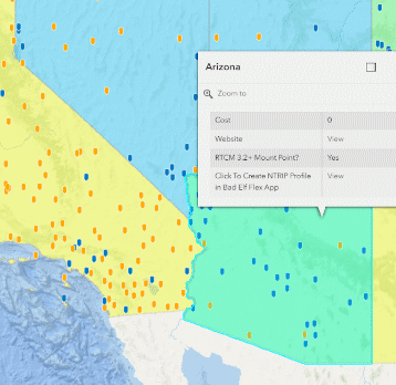
To address the lack of reliable information about public RTN availability, Bad Elf developed a web app. This interactive tool, built with ArcGIS Experience Builder, provides a clear visual overview of states offering public RTNs. It highlights networks that are free to use and those that support Multi-Signal Messages (MSM), a critical feature for modern receivers like the Bad Elf Flex Mini.

The app also offers practical tools to help you plan your project. You can easily access network websites and pre-configured profiles for the Bad Elf NTRIP client directly from the map. Plus, it displays the location of base stations and lets you measure baseline distances to assess potential accuracy, as more error is introduced with greater distances from the nearest base station.

RTK: More Than Just RTNs

While RTNs have made RTK more accessible, traditional base/rover setups still have their place. For projects requiring the highest accuracy or operating in areas with limited cellular coverage, a base/rover system might be the best option.

By providing a comprehensive resource and valuable insights, Bad Elf is committed to helping you harness the full potential of RTK technology.


Bad Elf Flex Mini Product Page
Bad Elf Geospatial Enablement Team
Bad Elf Flex Product Page
  • accuracy
  • High Precision Survey
  • high-accuracy
  • RTK
  • Share on Facebook
  • Tweet on Twitter
  • Pin on Pinterest

Nikolas Smilovsky
Nikolas Smilovsky

Dr. Smilovsky is the Geospatial Solutions Director for Bad Elf, a GNSS technologies company. Dr S is a faculty member at Arizona State University teaching various GIS and design classes. He is a certified Geographic Information Systems Professional, a certified Arborist, and a Part 107 certified UAV pilot. As a geospatial evangelist, custom geospatial solutions provider, and geographic researcher Dr. S is widely versed in all things geodetic. He is a proud Geoholic!


Post a comment

Please note, comments must be approved before they are published

Invalid password
Enter
Contact Sales

Looking for advice on a product or service? Speak with a member of our staff.

Need Help?

We're here to help you with all of your Bad Elf products. Browse recent FAQ's, our Knowledge Base, Glossary, and more.

Support

Our staff is ready to assist with your detailed questions.

Quick links

  • Home
  • My Subscriptions
  • Newsletter
  • Support
  • Store
  • Blog
  • Careers
  • Contact
  • About Us

Policies

  • Accessory Warranty
  • GPS / Electronics Warranty
  • Hardware EULA
  • MAP Policy (US)
  • Privacy
  • Reseller Program
  • Returns
  • Shipping

Connect with us on Social Media

  • Facebook
  • Twitter
  • Instagram
  • LinkedIn
  • YouTube
Use left/right arrows to navigate the slideshow or swipe left/right if using a mobile device
  • Choosing a selection results in a full page refresh.
  • Press the space key then arrow keys to make a selection.

Shopping Cart

No products in the cart.